Hiking Mt. Zhijiayang: Taiwan's Old Route to Xueshan with Epic Scenery
Located in Shei-Pa National Park, Mt. Zhijiayang (志佳陽大山) is a challenging yet rewarding hike that adventurous
trekkers dream about. Known as the "old route to Xueshan (Snow Mountain)", this trail is steeped in history
and offers breathtaking ridgeline views, lush forests, and panoramic grasslands that feel almost untouched.

At 3,345 meters, Mt. Zhijiayang is not for the faint of heart. But the reward is unforgettable—watching the
sunrise rising above Mt. Nanhu and Mt. Zhongyangjian, discovering hidden cabins like Piaodan Shelter, and
standing on the historic path that once led hikers to Taiwan's second-highest peak.

Disclaimer:
All content is for inspiration only. Use Taiwan Hikes' suggestions at your own risk. We are not responsible for any losses, injuries, or damages.
All content is for inspiration only. Use Taiwan Hikes' suggestions at your own risk. We are not responsible for any losses, injuries, or damages.
Table of Contents:
- Trail Information: Mt. Zhijiayang and the Extended Hike to Xueshan
- Maps, Transportation, Traffic Control on Provincial Highway 8, and Accommodation
- How to Apply for the Permits to Hike Mt. Zhijiayang and Snow Season Regulations
- Details of This Hike and Further Hike to Xueshan
- About Huanshan Tribe, (Qalang Sqoyaw) and Lishan
- Related Posts
Trail Information: Mt. Zhijiayang and Beyond
Mt. Zhijiayang Trail
Trail Name: Mt. Zhijiayang (Mt. Jhihjiayang or Mt. Sqoyaw)
Distance: 16.6 km (10.3 miles)
Route type: Out and Back
Days/Hours Needed: 12–14 hours, depending on your fitness level
Total Ascent/Descent: 1,920 m / 1,920 m
Best Time to Go: Spring, summer, and fall. Shei-Pa National Park requires hikers to have prior snow-hiking experience or training.
Permits: Park permit required. No need to apply for the police permit. Shei-Pa National Park requires training and additional gear if you plan to hike during the snow season.
Additional Information: Before your hike, please check Shei-Pa National Park Climbing Forums 雪霸國家公園登山資訊分享站 to see if the trail is open or other things that you need to know.
Difficulty Level:
Peaks or Places to Reach
- Mt. Zhijiayang 志佳陽大山最高峰, the highest point, 3,345 meters (10,974 feet) above sea level.
- Mt. Zhijiayang's triangulation stone 志佳陽大山, 3,289 meters (10,791 feet) above sea level.
- Sailianjiou Campground 賽良久營地 is at the 6 Km mark on the trail, 2,700 meters (8,858 feet) above sea level. Sailianjiou Campground capacity: 12 people. Hikers need to apply for permits to stay here. There is no water source nearby.
- Piaodan Shelter (Hut) and Campground 瓢單山屋和營地 is at the 7.2 Km mark, 3,145 meters (10,318 feet) above sea level. Piaodan Shelter capacity: 15 people; Piaodan Campground: 13 people. There are water tanks that collect rain on the side.

Extended Hike: Mt. Zhijiayang to Xueshan
Trail Name: Mt. Zhijiayang to Xueshan
Distance: 22.5 km (14 miles)
Route type: Point to point
Days/Hours Needed: 2 days at least
Total Ascent/Descent: 2,797 m/2,197 m
Best Time to Go: Spring, summer, and fall. Shei-Pa National Park requires hikers to have prior snow-hiking experience or training.
Permits: Park permit required. No need to apply for the police permit. Shei-Pa National Park requires training and additional gear if you plan to hike during the snow season.
Additional Information: Before your hike, please check Shei-Pa National Park Climbing Forums 雪霸國家公園登山資訊分享站 to see if the trail is open or other things that you need to know.
Difficulty Level:
Peaks or Places to Reach Other Than Mt. Zhijiayang
- Xueshan South Peak (South Peak of Syue Mt.) 雪山南峰 3,505 meters (11,499 feet) above sea level.
- Former Site of Xue Mountain Cabin (雪山山莊舊址營地), 3,340 meters (10,958 feet) above sea level. This is a campground, not a cabin. You need to bring your own tent and a sleeping bag. Campground capacity: 18 people.
- Mt. Syue, Xueshan, Mt. Snow, or Mt. Sylvia Main Peak 雪山主峰, 3,886 meters (12,749 feet) above sea level.
- Mt. Xue East Peak, Xueshan East Peak 雪山東峰, 3,201 meters (10,502 feet) above sea level.
- Sailiujiu Temporary Campground 三六九臨時營地, 3,150 meters (10,335 feet) above sea level. Campground capacity: 24 people.
- Qika (Cika) Cabin and Campground 七卡山莊和營地, 2,460 meters (8,071 feet) above sea level. Cabin capacity: 106 people; campground capacity: 30 people.

Maps, Transportation, Traffic Control on Provincial Highway 8, and Accommodation
GPX Track of Mt. Zhijiayang Hike
GPX Track of Mt. Zhijiayang to Xueshan
Click Menu in the map to download, print, or share the map.
You can see more options after clicking the Play button.
Click to change the speed to meet your condition.
You can see more options after clicking the Play button.
Click
to change the speed to meet your condition.
Buses from Yilan/Luodong to Lishan and Walk 2 Km to the Trailhead
- Take Kuokuang Bus 1751 from Yilan Transfer Station, or Kuokuang Bus 1764 from Luodong Transfer Station, and get off at Zhongxing Road Stop 中興路站.
- Walk around 2 Km to the trailhead (Google Maps).
- Or take Bus 866 (click Driving Map, and select "866" in the "Select Route" for details) to Lishan. Bus 866 only runs between Wuling Farm 武陵農場 (leaving at 6:30) and Tianchi Pod Daguan Pavilion 天池達觀亭 (leaving at 16:40). The closest bus stop to the trailhead/Xima B&B is Huanshan Tribe 環山部落.
Download the iBus app to make taking buses easier in Taiwan. Watch the following video about
how to use the iBus app to take bus 1751 or 1764.
Traffic Control on Provincial Highway 8 台8臨37線 (中橫便道)
Due to the constant typhoons and torrential rains, damage and landslides have occurred on Provincial Highway 8,
especially the section between Guguan and Lishan, which was closed to non-residents indefinitely.
For humanitarian reasons, Provincial Highway 8 Temporary Route 37 (Central Cross-Island Alternative Road)
台8臨37線(中橫便道) is open only for essential access for the Lishan residents, such as emergency medical aid and rescue.
Other than that, only public transport is allowed and scheduled to run in the Lishan area.
If you still need to drive there, please see the instructions for self-driving from the Tri-mountain
National Scenic Area, Tourism Administration, MOTC. Also, check the Provincial Highway Real-time Information
Service before you drive.
Accommodations
- Xima B&B No. 2 希瑪農莊2館 (Google Maps): right next to the trailhead
- Huanshan Huan Qing Temple 環山環清宮: the cheapest one among here.
- Wuling Hostel (Google Maps) near Wuling Farm. Wuling Hostel also provides private pickups.
- You can find other hotels in Huanshan Tribe/Village 環山部落.

Hire A Private Pickup to Save Time and Walk Less
You can consider staying at Wuling Hostel (Facebook page) near Wuling Farm and hire
their private pickup service to the Mt. Zhijiayang trailhead. Contact Mr. Huang (Terry) WhatsApp +886 (0)
983328960 for details. You will also find a restaurant and a small shop where you can purchase cartridges, snacks,
ramen, and other items.

How to Apply for the Permits to Hike Mt. Zhijiayang and Snow Season Regulations
Go to Hike Smart Taiwan Service 臺灣登山申請一站式服務網 and switch the language to English. The
application can only be sent between 7:00 - 23:00 (GMT+8). Click "Online Application" on the banner, and
then "Apply for Park Permit".


Doing Mt. Zhijiayang in A Day

Hiking Mt. Zhijiayang for 2 Days

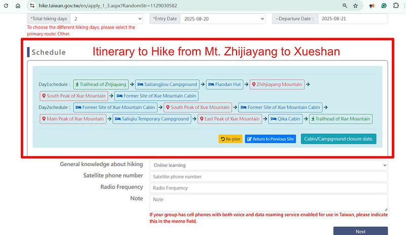
Hike from Mt. Zhijiayang to Xueshan for 2 Days

About Your Emergency Coordinator
Your Emergency Coordinator should know your hike and itinerary well, not just a random person you put on the
application form. You should let your Emergency Coordinator know your locations on the trail.


Permit Application Video
I have only included a short video and take the Yushan application as an example to help you understand how to
use the website. Hiking Xueshan doesn't require a police permit.
Please do your homework before you hike those popular trails. Several local governments have specific
regulations for activities in mountain areas. Please read the post Essential Guide to Hiking Regulations in Taiwan to avoid
unnecessary hefty fines.
Gear for Snow Season
The snow season is usually between mid-December/January and March. Shei-Park National Park has requirements for hikers during snow season.
The gear list from Shei-Pa National Park during snow season: a helmet, hiking boots and crampons (at least 10
points), gaiters, an ice axe, a headlamp, snow goggles, warm & waterproof clothing, wool socks, waterproof
gloves, and other essentials.

Details of This Hike and Further Hike to Xueshan
Brief itinerary:
Day 1: Xima B&B ➔ Sigilan (aka Sijielan) Creek Suspension Bridge ➔ Sailianjiou Campground ➔ Piaodan Hut/Campground ➔ Mt. Zhijiayang Stone (3,289 meters) ➔ Mt. Zhijiayang (3,345 meters) ➔ the Former Site of Xue Mountain Cabin
Day 2: The Former Site of Xue Mountain Cabin ➔ Xueshan Main Peak ➔ Sailiujiu Temporary Campground ➔ Xueshan East Peak ➔ Xueshan Trailhead
I started this hike in the dark, but I will share the daytime images to show you what this trail looks like.
Starting from Sijielan Suspension Bridge
01:28 We began our hike after a quick stop at Xima B&B. For NT$20, you can use
their toilets before heading to the Sijielan Suspension Bridge 四季蘭溪吊橋.


The early trail passes through cabbage farms, but stay alert because we got lost for a few minutes. A GPX map on
your phone is essential. Even with it, we made a few wrong turns in the dark.

01:38 We reached the permit mailbox and the signage for the small and big loops
of the Huanshan Hunters' Hiking Trail 環山獵人登山步道. A nearby post indicated it was 12.5 km to Peak of Syue Mt.
(Xueshan Main Peak).


The ascent grew steeper beyond the 3.1 km mark. If you're looking for a strenuous workout, this trail delivers.

05:39 We reached Sailianjiou Campground at 6 km. This is what it looks like
during the day.

Sunrise Through the Trees
06:20 Just when I thought we'd miss the sunrise, we stumbled upon a small forest
clearing around 6.6 Km. The view was magical—the sun rising above Mt. Zhongyangjian, casting light over a
rolling sea of clouds.

We later arrived at a slope facing Mt. Baigu 白姑大山, even though it wasn't facing the direction where the sun rises.
With the help of my PeakFinder app, I even spotted Yushan and Hehuanshan on the horizon.

07:15 We passed the junction to Mt. Mawuba 馬武霸山 at 6.9 km. Many hikers use this
alternative route to do a loop hike and avoid the steep descent, but I wanted to take photos in the daylight and
I enjoyed suffering.


Piaodan Shelter: The Cutest Cabin Ever. Plus, Grasslands and Expansive Views
07:53 We reached Piaodan Shelter 瓢單山屋 after the 7.2 Km mark. It stole my heart
immediately, tables and chairs outside face breathtaking ridgelines of Mt. Nanhu and Mt. Zhongyangjian 中央尖山.
This shelter was open for application after April 2023, which is still new.


To my delight, I even spotted Turtle Island 龜山島 far in the distance. I saw Turtle Island from the trail to Mt. Dabajian and Xueshan Main Peak. Now I can add
another place that can spot Turtle Island in my list.

We took a long, well-earned break here. Terry dozed off in a chair while I savored breakfast and admired the
view. The campground sits between the hut and the toilets with Mt. Dajian 大劍山 towering behind them.

According to the map, Piaodan Pond was behind the cabin, but I only saw a dry spot.
After taking a break for over one hour, we left Piaodan Shelter. The forest gave way to open grasslands offering
sweeping 360° views. Clouds drifted in and out, creating a dramatic landscape as we pushed toward the peak.

Mt. Zhijiayang's Summit: Two Summits Actually
09:31 We reached the Class 3 Triangulation Stone (3,289 meters) after the 7.8 Km
mark, a spot for photos even though it's not the highest point of Mt. Zhijiayang.

We continued to the actual summit, passing a post marking 4.5 km to Xueshan.
09:59 We stood on Mt. Zhijiayang's highest peak (3,345 meters) near the 8.3 Km
mark.

From here, you can see Xueshan's silhouette in the distance, a reminder of the old route hikers once took to
Taiwan's second-highest mountain. The trail ahead becomes far more treacherous and is only for seasoned
adventurers.

On our return, we caught sight of the tiny red roof of Qika Cabin, far across the valley on Xueshan's modern
route—a thrilling glimpse from this historic trail.


Considering the Hike to Xueshan?
If you're ultra-fit and want a serious challenge, you can extend your adventure to Xueshan (Snow Mountain).
The terrain between Mt. Zhijiayang and Xueshan is extremely rugged. Attempt this only if you have extensive
experience with multi-day alpine treks.

I want to thank my friends, Ola and Michal, for sharing their photos
during their attempt to hike to Xueshan via the Zhijiayang route. Although they had to abort their hike due to
the weather, their photos showed the treacherous terrain to Xueshan.

If you plan to hike to Xueshan via this route, it might take an extra 7 hours from the highest peak of Mt.
Zhijiayang based on the Sun River Map, a popular reference hikers use in Taiwan. So most hikers will camp at the
Former Site of Xue Mountain Cabin 雪山山莊舊址營地.
Although it has “cabin” in the name, there is no cabin at all. Moreover, hikers have to hike for almost 2 hours
(round trip) to get the water. Hikers who plan to stay at the Former Site of Xue Mountain Cabin also need to
apply for the park permit.
This route is extremely treacherous. After reaching Xueshan Main Peak, you take the popular Xueshan route (Xue Mountain Trail) to Wuling Farm.

About Huanshan Tribe, (Qalang Sqoyaw) and Lishan
Huanshan Tribe (Sqoyaw): Gateway to Taiwan's High Mountains
Huanshan, known as Sqoyaw in the Atayal language, is the largest Atayal village in the Lishan area. It's located
at the 61 km mark along Provincial Highway 7A 臺七甲線 in Pingdeng Village, Heping District, Taichung City
臺中市和平區平等里, near the upper reaches of the Dajia River 大甲溪 and within the catchment of Techi Reservoir 德基水庫.

Surrounded by towering peaks over 3,000 meters, like Mt. Nanhu, Mt. Zhongyangjian, and the Xueshan Range,
Huanshan earned its name, meaning “surrounded by the mountains.” It was once the trailhead for hiking Xueshan.

Due to frequent forest fires in the surrounding area, the Forestry Bureau established several firebreak trails
in the nearby mountains. In recent years, two of these trails have become popular routes for hiking Mt. Mawuba.
During the Japanese colonial period, the area was called Shinshe 新社, and a police outpost was established here
along the Piyanan Patrol Road 匹亞南警備道路. The name Zhijiayang 志佳陽 comes from the Japanese phonetic transliteration
of the original name.
Source: Shei-pa National Park
Source: Shei-pa National Park

Lishan: A Mountain Gem of Four Seasons and Fresh Produce
Situated at an average altitude of 1,900 meters, Lishan enjoys a temperate climate with mild weather and
abundant sunshine.

Its ideal environment produces renowned high-quality fruits and vegetables, including peaches, pears, apples,
and persimmons. In recent years, Lishan tea, baby cabbage, tomatoes, and kiwifruit have also gained popularity.

Visitors can enjoy fruit-picking experiences at local orchards and shop at the vibrant fruit markets to take
home a taste of the mountains. Thanks to its high-altitude setting, Lishan offers seasonal beauty
year-round—from flower viewing in spring (January to April), to colorful autumn foliage, and snowy landscapes in
winter.
Lishan is also home to a diverse community, including Hakka, Hoklo, and retired military personnel. Indigenous
Atayal people live in scattered settlements such as Huanshan and Songmao villages.
Sorce: Tri-Mountain National Scenic Area
Sorce: Tri-Mountain National Scenic Area
